- A thunderstorm rolled in, splashed Zion Canyon with a little rain, and soon transient waterfalls streamed in narrow ribbons down the sheer walls of the canyon.
Not much can top the Grand Canyon in Arizona for an awe-inspiring example of geology, but southern Utah comes close. It’s one awesome view after another. Sorry for the adjectival pile-up, but it’s incredible, monumental, expansive, panoramic, spectacular, magnificent, ancient, jaw-dropping, gorgeous…You get the idea. (A map and links to cards I designed, videos and websites about the parks, geology and other fascinating facts are at the bottom of this post. All photographs are copyrighted. Some are available as greeting cards, mouse pads and other products at It’s a Beautiful World! Thumbnails are at the bottom of this post.)
On November 1, my husband and I flew into Las Vegas, rented a car and headed northeast to Zion National Park. Joshua trees stood like sentries along the highway that cut through the bright, bleak, arid landscape.

The Virgin River cuts a swath through Zion Canyon.
We left Nevada, crossed a corner of Arizona and headed up the Virgin River Valley in Utah at dusk. The trip didn’t take long, but night comes early in November. The setting sun cast a warm glow on the mesas, but it was dark by the time we arrived at Zion Lodge, where we checked into a cabin.

A pair of extremely rare California Condors chase each other in the Big Bend area of Zion National Park. Hopefully, baby condors will result.
During the night, we heard rain pelting the roof. “Uh, oh.” Zion Canyon only gets about 12 inches of rain a year, and we were lucky enough to witness an inch of it. We got our first view of the gorgeous peaks as the storm clouds boiled in and drifted like smoke between the crags.
We took a shuttle, required during the high season, from site to site. We waited at the first shuttle stop until the rain passed, then started up a path. Soon lightning flashed, and almost immediately thunder cracked like cannon fire. Standing under the trees didn’t seem like a very safe place to be. Luckily the storm passed, and sunlight revealed the vivid golds of the cottonwoods and the brilliant red of the maples.
A shuttle passenger told us about a pair of California Condors he’d spotted at the Big Bend area. We were excited to see these endangered birds, which were re-introduced to Zion. They have the largest wingspan of any bird in North America, but they were still difficult to see. One condor seemed to be chasing the other from tree to tree.
The California Condors are some of the rarest birds, with only 332 known in existence, including 156 in the wild, as of August 2008. In 1987, there were only 22 California Condors, all in captivity, but a captive breeding program has increased their numbers. We were lucky to see them.

The "pulpit" on the left and the "altar" on the right are natural rock monuments in the Temple of Sinawava at the end of the road in Zion Canyon. A riverside walk along the North Fork of the Virgin River continues until the cliffs narrow. To continue, you have to hike in the water.
I promise I won’t make this a minute by minute account of this trip, but let me just say that my mouth was hanging open half of the time, amazed at the number of exquisitely beautiful ways that rocks can erode. Southern Utah is called color country, and I was reminded of my tubes of oil paints. So many lovely earth tones, the rocks and the vegetation were so beautifully color-coordinated: Russet, naples yellow, yellow ochre, burnt sienna, lavender, unbleached titanium, olive, green, cadmium orange, rusty, pink, salmon, beige, gray.

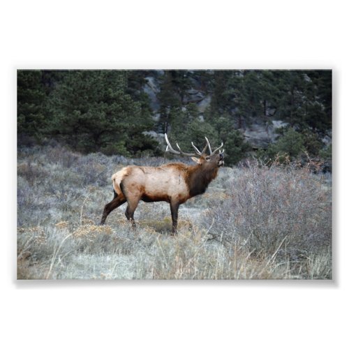
Mule deer were the most common animal that we saw in Utah. They were busy browsing day and night.
Here are the parks we visited or at least drove through, making a big loop, November 1-7:
-
Zion National Park
-
Bryce Canyon National Park
-
Grand Staircase National Monument
-
Capital Reef National Park
-
Glen Canyon National Recreation Area (the White Canyon area)
-
Canyonlands National Park (Needles and Island in the Sky sections)
-
Arches National Park
-
Dead Horse Point Utah State Park
-
Zion National Park (again)
Zion National Park will celebrate a hundred years as a protected area in 2009. After leaving Zion, we drove through the Zion-Mt. Carmel tunnel, which at 1.1 miles, was the longest tunnel in the United States when it was dedicated on July 4, 1930. Traffic can only go through one way at a time, because of the tunnel’s narrowness.
At Bryce Canyon National Park, you view the canyon from the plateau’s rim, rather than at the bottom as you do at Zion. You can take trails to the bottom, but we didn’t because it was cold and windy. At Zion, you start from the valley floor, hiking to the top of the mesa — if you get that far.

Hoodoo close-up.
Everywhere in Bryce Canyon are hoodoos, which are pillars and spires of rock, usually in a fantastic or odd shape, created by erosion. The hoodoos are a wide range of hues of reds, pinks, salmon, yellow and white. The Bryce Canyon hoodoos have been called grotesque, eerie, even whimsical. One definition of hoodoo is “to cast a spell,” which they definitely do. Was I enchanted? Absolutely.
Technically, Bryce isn’t a true canyon, because it wasn’t carved by flowing water, such as a stream or river, but etched by acidic rainwater and altered by freezing and thawing. The acid dissolved the limestone, rounding the edges of the hoodoos. Freezing and thawing of water did most of the sculpting, which happens about 200 days a year.

Bryce Canyon is full of fantastic hoodoos. Here is a view from Inspiration Point.
Heading east, beyond Bryce Canyon, we climbed into mountains, where the beauty of fall had already passed. The aspens had all lost their leaves and were ghostly skeletons on the mountainsides. We drove mile after mile down into valleys, where water and wind had carved more mesas and buttes. We passed through a few small mountain and high desert towns, but then for a couple of hours, we saw no sign of humanity except the black ribbon of asphalt that curved through the ancient landscape. We only saw a little of the Grand Staircase National Monument, but enough to see that it’s aptly named. We also saw some of Capital Reef National Park, which does look like an ancient ocean reef stranded on land.
The strata of millions of years were visible as the forces of the earth create rock and then wear it away in an endless cycle. Sometimes, a lone building would stand in a deep shadowed valley by a narrow river, lined by a profusion of trees and shrubs.

Near Canaan Peak, 9,196 feet, between Henrieville and Escalante, Utah.

Mormon pioneers in the 19th century carved out farms and orchards along rivers in this very arid land.
The road rose and fell, curved and cut through ridges that looked like a row of mastodon teeth or the undulating vertebrae of an ancient serpent. We took the road along the White Canyon, crossing over Glen Canyon, as we headed toward Moab.

A section of Glen Canyon near Hite, Utah.
We stopped for the night in Monticello, Utah, where we ate at a family-run business. The hostess/waitress/owner asked how we came to be so far from home. Maybe she forgot about all of the amazing scenery just outside her door! Her young son solemnly asked whether he could remove our empty dishes. I hated to disappoint him when he asked us whether we wanted dessert, but we were stuffed.

You don't see many cattle in this arid land. Most are free range, wandering across the land. Signs along the highway warn you to watch out for them. Here are cattle at the historic Dugout Ranch, south of the Needles section of Canyonlands National Park, Utah.

The Needles of Canyonlands National Park march across the horizon.

The north section of Canyonlands National Park is the Island in the Sky mesa in the center. This photograph is taken in the Needles district of the park in the Pothole area. Shallow potholes in the rock in the foreground, when filled with rain or melted snow, provide homes for a variety of animals.

You feel really small at Arches National Park.

Balanced Rock at Arches National Park reminds me of a Disney cartoon. The rock on top is the size of three school buses.

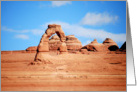
Delicate Arch in Arches National Park is the unofficial symbol of Utah. See the tiny person underneath. We hiked uphill a half a mile to see it from this vantage. Others hiked several miles to hike underneath.

Landscape Arch in Arches National Park is one of the longest natural bridges in the world -- as long as three football fields. Pieces keep falling, so that the thinnest area is only three feet wide. Find out more about Landscape Arch in a link to a movie about Arches National Park below.
The soft red sandstone of Arches easily erodes, returning to the original sand of millions of years ago. The wind whips it up, swirling it around, until it gets into every orifice on your head. The geologic features of Arches and the other parks in Utah are a testimony to the ancient forces of the earth. These features come in an amazing array of styles from spires to fins to crags to buttes and mesas, as well as arches. There are more than 2,000 known natural sandstone arches in Arches National Park. They take eons to form, but can quickly collapse.

In Arches National Park, Wall Arch, near Landscape Arch, collapsed on August 4, 2008. Hikers found the rubble the next day. Wall Arch was the first major arch to fall in 17 years.
Guidebooks suggest getting to Mesa Arch in Canyonlands National Park at sunrise for the best view. The park was more than thirty miles from our hotel in Moab, the temperature was in the thirties, there was snow on the ground, I didn’t bring warm enough clothes — as usual. Sunrise? Not gonna happen.
But I couldn’t sleep. We were dressed, packed, ate breakfast, checked out and on the road by 7 a.m. It was freezing, so I shot up the more than half-mile trail to the arch, hoping to get there as fast as I could so I could get back to the warm car. I started snapping photographs as soon as I saw the arch. It was about 8 a.m., and the early morning sun cast a fluorescent orange glow on the arch. Golden light splashed the valley below. It was an incredible view. I could hardly make myself leave. I forgot I was cold until we started walking back to our car.

Mesa Arch glows just after sunrise in the Island in the Sky section of Canyonlands National Park, Utah.

We hiked to this strange geologic feature in Canyonlands, which looks like a crater. It could be a meteor crater from 60 million years ago or a salt dome.
The Canyonlands and Arches area gets about ten inches of precipitation a year, half of it in snow. We saw some of the snow that morning and had to brush it off the signs. After Canyonlands, we went to Dead Horse Point State Park, which is nearby. The point sits on a plateau at an elevation of about 6,000 feet above sea level. You can see 300 million years of the earth’s geologic history. On the canyon rim you can see the Colorado River below. There are 8,000 feet of geologic strata visible from the peaks of the 12,000-foot-high La Sal mountains reaching to the river below.
I’m gratified that you’re read this far. I’ve barely scratched the surface…..But I’ll give you a break. We missed so much, too, including Monument Valley and some great Native American pictographs. There wasn’t enough time — and time is something you’re very aware of in southern Utah, even when it everything seems so timeless. Zane Grey’s pioneering 1912 novel, “Riders of the Purple Sage” was set in this area.
Many movies were filmed in southeastern Utah, so that these photographs might look familiar to you, but no movie or photograph can capture the majesty of the place. I’ll write “More Awesome Utah” in a week or so with some Las Vegas thrown in for contrast. Be sure to check out the links to websites and videos below the photo at Dead Horse Point, where 19th century cowboys corralled wild horses, which sadly died from thirst.

The Colorado River takes a sharp turn at Dead Horse Point State Park.
Links to websites and videos:
Here is a collage card I designed of nine beautiful Utah scenes.
 Click on the card thumbnail.

Utah and surrounding states.